


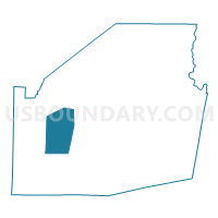
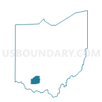
Voting District HAMER, Highland County, Ohio
About
Outline

Summary
| Unique Area Identifier | 647925 |
| Name | Voting District HAMER |
| County | Highland County |
| State | Ohio |
| Area (square miles) | 22.63 |
| Land Area (square miles) | 22.56 |
| Water Area (square miles) | 0.08 |
| % of Land Area | 99.65 |
| % of Water Area | 0.35 |
| Latitude of the Internal Point | 39.15173220 |
| Longtitude of the Internal Point | -83.74272330 |
Maps

Graphs
Select a template below for downloading or customizing gragh for Voting District HAMER, Highland County, Ohio


Neighbors
Neighoring Voting District (by Name) Neighboring Voting District on the Map
- Voting District CLAY, Highland County, OH
- Voting District DODSON, Highland County, OH
- Voting District NEW MARKET NW, Highland County, OH
- Voting District SALEM, Highland County, OH
- Voting District UNION, Highland County, OH
- Voting District WHITEOAK, Highland County, OH
Top 10 Neighboring County Subdivision (by Population) Neighboring County Subdivision on the Map
- Dodson township, Highland County, OH (2,607)
- Union township, Highland County, OH (2,065)
- New Market township, Highland County, OH (1,888)
- Clay township, Highland County, OH (1,431)
- Whiteoak township, Highland County, OH (1,371)
- Salem township, Highland County, OH (780)
- Hamer township, Highland County, OH (680)
Top 10 Neighboring Unified School District (by Population) Neighboring Unified School District on the Map
- Hillsboro City School District, OH (16,550)
- Lynchburg-Clay Local School District, OH (6,575)
- Bright Local School District, OH (4,960)